International Satellite Internet and Successfully Launch Intelsat 17 Satellite-

BusinessCom has been providing international satellite Internet access solutions through an extensive network of ground station facilities and geostationary satellite spacecraft fleet since 2003.
With coverage now including all of Africa, Asia, Middle East, Europe, CIS and Americas, our mission is to deliver high performance applications centric global satellite Internet connectivity services to residential customers, businesses and voice/data carriers. Our success providing satellite Internet worldwide is based on premium quality of infrastructure, a custom tailored approach to every client, skill strength of our personnel, proven and innovative global satellite Internet technologies such as Deterministic TDMA and DVB-S2 backed up by highly competitive pricing.
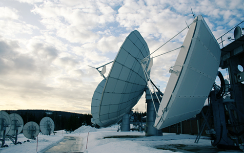 Nittedal Earth Station in Norway, one of the terrestrial IP interconnection and uplink ground facilities used by BusinessCom worldwide satellite Internet access
 By using BusinessCom world wide satellite Internet access it is now possible to deliver broadband IP connectivity virtually to any point on Earth, with content delivered at very high speed. Our international satellite Internet services fully support QoS and provide toll quality VoIP and videoconferencing with the ability to prioritize mission critical applications such as VPN, SCADA, Resource Management, CITRIX applications and other traffic by IP ranges, ports, ToS and diffserv bits. This is achieved by using QoS built into the satellite modem or BusinessCom Traffic Engineering Server (TES) appliance. With optional built in or external encryption facilities, BusinessCom global satellite Internet circuits are very secure. With dedicated global satellite Internet backbone connectivity solutions based on SCPC and DVB-S2 platforms, BusinessCom delivers up to a full satellite transponder capacity through a small aperture antenna terminal installed at customer premises. This allows to quickly deploy independent IP networks and support many thousands of subscribers through wireless or terrestrial last mile extensions.
International Satellite Communications System
(ISCS)-

Purpose:
The purpose of ISCS is to provide timely delivery of critical aviation-related weather information to support air traffic management and flight operations in over 80 countries, and regional meteorological telecommunications between The United States and nations in The Caribbean and Central America.
To all ISCS/RMTN (Transmit- Receive) users:
On 31 March 2010; beginning at 07:00 PM (EDT) the two-way (transmit/receive) portion of the ISCS will no longer be operational. There will be no disruption/discontinuation of the ISCS broadcast.
Once the two-way portion of the ISCS no longer operational; the ISCS satellite capability will be broadcast only. ISCS sites that had been transmitting their OPMET data to the NWSTG FTP server via the ISCS satellite should use Email ingest to perform that function.
Once the two-way portion of the ISCS no longer operational; the ISCS satellite capability will be broadcast only. ISCS sites that had been transmitting their OPMET data to the NWSTG FTP server via the ISCS satellite should use Email ingest to perform that function.
A todo el ISCS/RMTN (Transmita- Recibe) usuarios:
El 31 de Marzo 2010; empezando a las 07:00 de la tarde (EDT) la dos-manera (transmite/recibe) porción del ISCS ya no será operacional. No habrá interrupción/discontinuación de la transmisión de ISCS. Una vez que la porción de dos-manera del ISCS ya no operacional; la capacidad de satélite de ISCS será transmitida sólo. ISCS sitúa que había estado transmitiendo sus datos de OPMET al servidor de NWSTG FTP a través del satélite de ISCS debe utilizar Correo electrónico ingiere para realizar esa función.
Product Collection and Dissemination
For International Satellite Communications System (ISCS)-
ISCS uses three INTELSAT satellites to disseminate meteorological products to users -- INTELSAT 903 over the Atlantic Ocean, and INTELSAT 701 over the Pacific Ocean, INTELSAT 906 over the Indian Ocean (see ISCS operations Footprints). ISCS satellite uplinks (ground stations), are located at three Verizon International Gateways. Andover Maine covers the Atlantic Ocean region, and Yacolt Washington covers the Pacific region while Fuchsstadt Germany covers the remainder of the Pacific region - eastern Asia.
Data in TCP/IP protocol, is sent from the National Weather Service Telecommunications Gateway (NWSTG), in Silver Spring, MD, to the Verizon International Gateway in Andover, Me, via redundant terrestrial links at 128 kilobytes per second. From Andover, data is sent directly to the INTELSAT 903, INTELSAT 906 satellites, and also to the INTELSAT 701 satellite (through the Yacolt, WA International Gateway via terrestrial link from Andover), for broadcast to users within each satellite footprint. The satellite broadcast is a C-band (5-6 Ghz system), with a data rate of 128 kilobytes per second. The communications protocol over the satellite is a Hughes Communications satellite protocol.
Reception of the satellite broadcast is based on the Very Small Aperture Terminal (VSAT) technology, consisting of a 2.4 meter parabolic antenna. Other required hardware at receiving sites includes the radio receiver, satellite modem, and a user workstation to receive and process the satellite broadcast. Workstations may be purchased from any suitable vendor.
Intelsat 17 satellite Launch Successful-
Arianespace successfully launched the Intelsat 17 satellite (IS-17),
26 November 2010. The Ariane 5 vehicle lifted off from Kourou, French Guiana, at 1:39 p.m. EST, followed by spacecraft separation and signal acquisition at approximately 2:06 p.m. EST.
The satellite, built by Space Systems/Loral, will provide C- and Ku-band capacity across Europe, the Middle East, Africa, Russia and Asia from the 66º E orbital location. IS-17 is an important addition to the Intelsat fleet, expanding its successful Asian video distribution neighborhood located at 68.5º E, on the Intelsat 10 satellite. This satellite will replace the Intelsat 702 satellite and is designed to provide service for the next 16 years. IS-17 is slated to enter service in the first quarter of 2011.
Station Sightings-
 July 24, 2000 -- As the Russian service module "Zvezda" nears its July 25 rendezvous with the International Space Station, stargazers and space enthusiasts can track the progress of construction on the ambitious space research facility.
 And they can do it with the naked eye.
A new web site developed at NASA's Marshall Space Flight Center in Huntsville, Ala., is making it easy and exciting for enthusiasts across the country and around the world to catch a glimpse of the orbiting facility.
Right: Under construction: the International Space Station. After the Zvezda Service Module is added this week to the combined Zarya (bottom) and Unity (top) modules, the assembly will be brighter than ever.
The "Where is the International Space Station?" site lets users identify the orbiting Space Station and determine in advance when it will pass over their hometowns.
The site relies on a sophisticated, Java-based program called J-Pass, developed by Patrick Meyer, a data systems engineer at the Marshall Center.
J-Pass displays user-friendly tracking information provided by the North American Aerospace Defense Command (NORAD). It permits site visitors to track not only the International Space Station, but also the Russian station Mir, Space Shuttle missions, and other objects in Earth orbit.
Images for satellite-


End of life-
When satellites reach the end of their mission, satellite operators have the option of de-orbiting the satellite, leaving the satellite in its current orbit or moving the satellite to a graveyard orbit. Historically, due to budgetary constraints at the beginning of satellite missions, satellites were rarely designed to be de-orbited. One example of this practice is the satellite Vanguard 1. Launched in 1958, Vanguard 1, the 4th manmade satellite put in Geocentric orbit, was still in orbit as of August 2009.
Instead of being de-orbited, most satellites are either left in their current orbit or moved to a graveyard orbit. As of 2002, the FCC now requires all geostationary satellites to commit to moving to a graveyard orbit at the end of their operational life prior to launch.Launch-capable countries-
Main article: Timeline of first orbital launches by nationality
Launch of the first British Skynet military satellite.
This list includes countries with an independent capability to place satellites in orbit, including production of the necessary launch vehicle. Note: many more countries have the capability to design and build satellites but are unable to launch them, instead relying on foreign launch services. This list does not consider those numerous countries, but only lists those capable of launching satellites indigenously, and the date this capability was first demonstrated. Does not include consortium satellites or multi-national satellites.
First launch by country Order 
Country Year of first launch Rocket Satellite 1  Soviet Union
1957 Sputnik-PS Sputnik 1 2  United States
1958 Juno I Explorer 1 3  France
1965 Diamant Astérix 4  Japan
Japan1970 Lambda-4S Ōsumi 5  China
China1970 Long March 1 Dong Fang Hong I 6  United Kingdom
1971 Black Arrow Prospero X-3" 7  India
India1980 SLV Rohini 8  Israel
1988 Shavit Ofeq 1 _  Russia
1992 Soyuz-U Kosmos 2175 _  Ukraine
1992 Tsyklon-3 Strela 9  Iran
Iran2009 Safir-2 Omid While Canada was the third country to build a satellite which was launched into space, it was launched aboard a U.S. rocket from a U.S. spaceport. The same goes for Australia, who launched on-board a donated Redstone rocket. The first Italian-launched was San Marco 1, launched on 15 December 1964 on a U.S. Scout rocket from Wallops Island (VA,USA) with an Italian Launch Team trained by NASA. Australia's launch project (WRESAT) involved a donated U.S. missile and U. S. support staff as well as a joint launch facility with the United Kingdom.
History of artificial satellites-
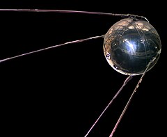
Sputnik 1: The first artificial satellite
The first artificial satellite was Sputnik 1, launched by the Soviet Union on October 4, 1957, and initiating the Soviet Sputnik program, with Sergei Korolev as chief designer (there is a crater on the lunar far side which bears his name). This in turn triggered the Space Race between the Soviet Union and the United States.
Sputnik 1 helped to identify the density of high atmospheric layers through measurement of its orbital change and provided data on radio-signal distribution in the ionosphere. The unanticipated announcement of Sputnik 1's success precipitated the Sputnik crisis in the United States and ignited the so-called Space Race within the Cold War.
Sputnik 2 was launched on November 3, 1957 and carried the first living passenger into orbit, a dog named Laika.
In May, 1946, Project RAND had released the Preliminary Design of a Experimental World-Circling Spaceship, which stated, "A satellite vehicle with appropriate instrumentation can be expected to be one of the most potent scientific tools of the Twentieth Century. The United States had been considering launching orbital satellites since 1945 under the Bureau of Aeronautics of the United States Navy. The United States Air Force's Project RAND eventually released the above report, but did not believe that the satellite was a potential military weapon; rather, they considered it to be a tool for science, politics, and propaganda. In 1954, the Secretary of Defense stated, "I know of no American satellite program."
On July 29, 1955, the White House announced that the U.S. intended to launch satellites by the spring of 1958. This became known as Project Vanguard. On July 31, the Soviets announced that they intended to launch a satellite by the fall of 1957.
Following pressure by the American Rocket Society, the National Science Foundation, and the International Geophysical Year, military interest picked up and in early 1955 the Air Force and Navy were working on Project Orbiter, which involved using a Jupiter C rocket to launch a satellite. At first, they failed: the launch vehicle had a strange and uncanny way of exploding on national television. But finally, three months after Sputnik 1, the project succeeded; Explorer 1 thus became the United States' first artificial satellite on January 31, 1958.
In June 1961, three-and-a-half years after the launch of Sputnik 1, the Air Force used resources of the United States Space Surveillance Network to catalog 115 Earth-orbiting satellites.
The largest artificial satellite currently orbiting the Earth is the International Space Station.
- From Wikipedia-
No comments:
Post a Comment